A Swiss Alps hike: Rotstockhutte to Murren
If I made a list of hiking meccas by country, Switzerland would land in my top 5. When I traveled to Europe for the first time, my priority was to find some of the best hikes in the Swiss Alps.
At the time, my Parkinson’s diagnosis was about 4 years old. My doctor had no objections to my plans to romp around Switzerland and wished me well. I was feeling ready, having upped my exercise routine at the gym to include more stair-stepping.
For an overview of my experience hiking the Swiss Alps, check out this post. It may help you decide whether you should pursue a Swiss hiking trip, especially if you have Parkinson’s disease.

My three hiking pals – husband, brother and sister-in-law – and I had done the research and felt we had chosen some of the top hikes in Switzerland, some easier, some harder. This post details one of the hikes, and future posts will cover two more. They are:
- Five Lakes Trail to Stellisee and Fluhalp hut, Zermatt region
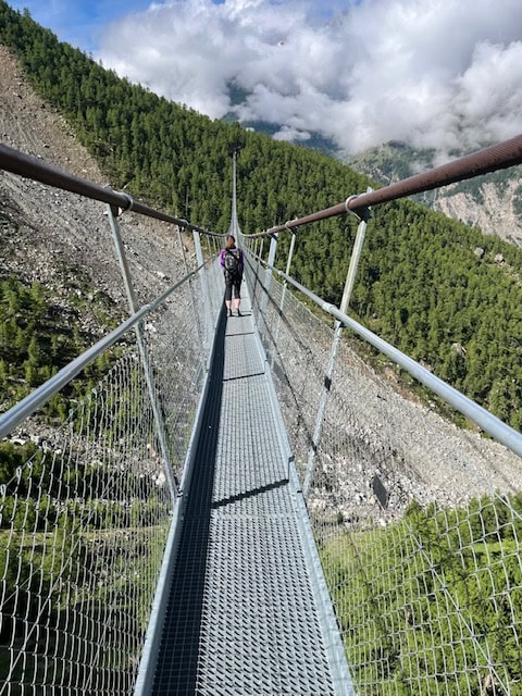
- Charles Kuonen Suspension Bridge, Randa
Parkinson’s hiking tip
A trip like this can be stressful and is not without risks. Consult your medical professionals and get the OK before you begin planning.
Rockstockhutte to Murren
(Jump to hike stats.)
Murren, in Switzerland’s scenic Interlaken area, is a mountainside town most easily reached by gondola, also called a cable car, from Stechelberg.
Many people opt to begin their trek in Murren, hike up to Rotstockhutte to stay for a day or two, then go back to Murren. That’s a good option for hikers concerned about fatigue and exposure to falls. You’d be trekking a moderate-rated trail up to the hut, then down to get back.

We did something a little different. Our route was a big loop that included one night at Rotstockhutte and ended in Murren, where we could take the cable car back down to the station in Stechelberg.
On our first day, the cable car brought us from Stechelberg to the top of Mount Schilthorn. Most of those aboard were going up solely for the views and perhaps some browsing in the tourist shop at the peak. Others were hikers like us — their backpacks were our first clue.

For us there was no dilly-dallying at the top. After taking in the view, we started our trek to the Rotstockhutte.

Getting there was literally all downhill, the trail descending about 3,000 feet from Schilthorn’s 9,750-foot-high peak. The path was well-marked with blazes of red and white painted on rocks.
We took it slowly and carefully – we knew what the stats say. More people are injured while hiking down a mountain than while going up. It was 2-3 hours – with lots of rest stops – before we saw the hut for the first time. Hallelujah!

But it was still a couple of hours away.
Along the route, the wildflower show was spectacular. That kept me distracted from the aches and pains I was feeling.


About the hut
Rotstockhutte is in the middle of nowhere and can be reached only on foot. A helicopter drops off supplies every few days.
I had read about the famous Swiss hiker huts, and I was excited to see what they were like.
Our reservation included dinner, beds, and breakfast.


There were several house rules to keep order.
One was to remove your hiking boots and grab a pair of Crocs in your size from a shelf to wear when inside the hut. It was ingenious! So many muddy and dusty boots would make a mess.
After a dinner of soup and bread, the guests began to settle into their assigned beds, all lined up in a very spartan upstairs room.

The shared bathroom was separate from the main house and had flush toilets and running water.
The next morning we geared up for our trip down to Murren. We had packed as light as we could for the two-day trip. For the record, our backpacks contained:
- Clothing layers, extra socks
- Filled water bottles
- Snacks
- First-aid kit
- Trekking poles
- A few other personal items (including my medication!)
Parkinson’s hiking tip
When on the trail, I like to keep my medication in a secure, zippered pocket that’s easy to get to, either in my clothing or in the handy pocket on the front waist strap of my backpack. They make small items easily accessible, but not all packs have them.
The hike down to Murren
The trailhead was just outside the hut’s gate; when you walk through it, take a right.
The first part of the route was relatively flat as it meandered through pastures of cows. The animals kept their distance, but the cowbells around their necks gave us delightful background music to hike to.

In total we had about 4 miles to traverse and 1,400 feet of elevation to lose.
After 2 miles we came to the section where most of the elevation would be lost. A dozen short switchbacks later, we hit bottom of the valley and came to a farming area and a tiny village. There was even a little cafe, but it didn’t look open.
Parkinson’s hiking tip
When going down steep stairs, use of trekking poles cannot be emphasized enough. (Think of the emoji with two exclamation marks!!) Poles will ease pressure on your knees while providing stability. If you don’t want to use two poles, use one.

We walked through the farming area, and the trail then took us through a forest with mini ups and downs. When we came to this sign, we knew we were close.
Paragliders flew right overhead from their launch a few hundred feet above us. It was beginning to rain, and we were glad the rest of the way to Murren was paved.
We walked back to the cable car station, bought our tickets, and enjoyed the ride to the bottom. Next stop: Zermatt region!
Hike info
PD difficulty level (see chart): moderate
Distance: 3.8 miles point-to-point
Elevation loss: 1381 feet
Trailhead location: just outside Rotstockhutte
Cell phone service: not on trail
Bathrooms: At the hut and at the cable car station
Emergency medical support: Walk-in clinic is in Interlaken, 24 minutes from Stechelberg. Call +41 900 57 67 47. (Clinic in Murren is open only in winter.)
Costs: Cable car ticket was approximately $110 going up about half that going down from Murren
Insider tip: The Murren cable car is closed during a period in fall and spring for maintenance. Check this website and scroll down to “Lauterbrunnen Murren Cable Car” for the schedule.
(Back to top)

Do you have a favorite hike in Switzerland, or elsewhere in Europe? Comment about it below!


One Comment